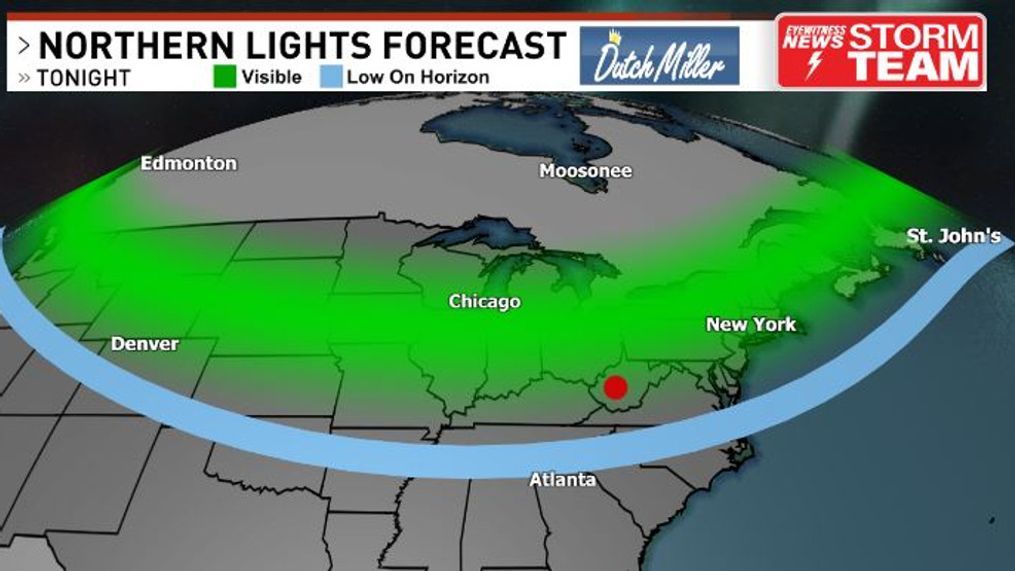
Northern Lights may be visible throughout the region late Friday night
CHARLESTON, W.Va. (WCHS) — The last time the Space Weather Prediction Center issued a Severe Geomagnetic Storm Watch was nearly 20 years ago back in 2005. Another one has been issued one for this upcoming weekend.
What does this mean? It means the sun is blasting an abnormally high amount of charged particles at earth via solar flares.
This has happened countless times before, and there's no risk to our health - the magnetic field that surrounds us in the upper atmosphere deflects this energy away and above the polar regions, and this is why the Northern (and southern) Lights are typically found there.
Those charged particles coming from the sun colliding with oxygen and nitrogen gas high in our atmosphere is what causes these brilliant dancing colors. Every so often, though, like this weekend - the solar energy heading our way can be so intense that aurora borealis can be found unusually far south.
There is a good chance, given the strength of this solar storm, that our region will see the Northern Lights. Even places in the deep south could catch a glimpse!
There is a downside to this beautiful sight, though - it can disrupt communications and possibly even impact the power grid.
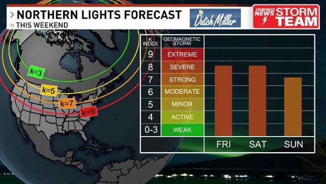
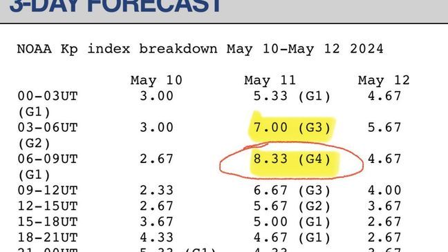
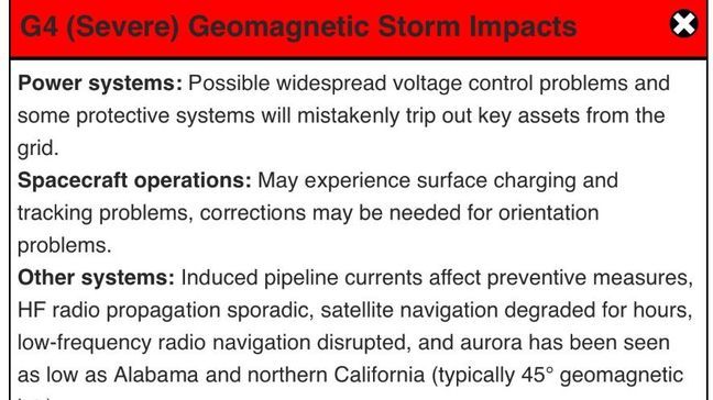
The G scale goes from one to five, and the higher you go - the more severe the geomagnetic storm is. Tonight, a G4 is expected. Here's what can happen with a storm of this magnitude per NOAA's Space Weather Prediction Center:
We actually had a G4 earlier this year in March, as we are in an active cycle with the sun.
The last G5, or extreme, geomagnetic storm, was back on Halloween in 2003. I vividly remember seeing red in the sky during trick-or-treat in Sissonville - how fitting is that? That event resulted in brief power outages in Sweden and damaged power transformers in South Africa.
According to the latest forecast, the peak energy reaching the earth's upper atmosphere - via the K or Kp index seen below - will occur roughly around midnight to 5 a.m. in the early morning hours of Saturday. This will be the 'sweet spot' of possibly seeing the northern lights.
Could you see some before and after that time? It's possible, but those will be the best times.
If you want to take a look tonight, you'll want to get away from as many lights as you can and have a good view of the northern sky. Your eyes may need some time to adjust. Certain cameras will be able to catch it easier.
The forecast looks optimistic. After some clouds today, they will gradually thin even more as the evening goes on. It will be turning chilly, though - so don't forget a jacket. If you snap any pictures, we would love to see them! Feel free to send those over to us by clicking here.
Elsewhere, there were certainly some towering clouds Thursday evening with scattered showers and thunderstorms developing. I watched this smaller cumulus turn into a cumulonimbus in a matter of minutes looking southeast from Sissonville.
A few of these storms, given a combination of some instability and environmental wind-shear, turned strong to severe - particularly further north closer to the front.
In Lewis County - just north of Braxton - there were reports of trees down on homes.
There was also enough 'turning' of the environmental winds in the lower portion of the atmosphere to allow for some rotation in these cells. In fact, there's some video of a probable funnel cloud (at least) that occurred east of Parkersburg around 8:20 p.m. It aligns well with how the radar looked at that time - showing a cell with a distinct kink over that region.
Also, the wind scan showed what we call a 'velocity couplet' - a tight area within the storm with a contrast in wind direction. This suggests a tornado may have occurred.
At the time of this writing (11 a.m.), the National Weather Service in Charleston is currently investigating this. If a tornado is verified, this would be the 12th in West Virginia this year - a state that only averages two per year.
As for Friday, no severe weather is forecast - but it is much cooler behind the front. It almost gives me fall vibes given the clouds, cooler temps and slight breeze.
Later Friday afternoon, some peeks of sun will likely emerge - and given a low freezing level today, thunderstorm-like showers will likely grow upwards. They'll be scattered in nature, but may contain pea-sized hail given the colder air aloft.
While scattered clouds and a few showers can still be around near sunset - clouds should really begin to clear later in the evening, allowing for good viewing conditions of the northern sky.
Patchy fog will form across some valleys, though - and it will be turning chilly given the drier air in place. Many of us will fall well into the 40s by dawn Saturday.
As for the weekend, it looks split. Saturday will feature gusty showers and possibly a few thunderstorms in the afternoon - while the weather looks great for Mother's Day on Sunday! Those A/Cs can certainly catch a break with these temps.
Saturday morning will be pleasant out ahead of the front with some sun. This will be the best time to mow your lawn as we'll warm up into the 60s by lunchtime.
By around lunchtime Saturday, or shortly thereafter, a gusty line of showers and embedded thunderstorms will move in. There's a chance there could be an isolated stronger storm. However, at least expect an hour or so of rainfall and likely some hail in the stronger cores.
As this quickly moves through, scattered thundershowers might develop behind it. Temps will likely fall into the 50s during the steadier showers before rebounding with some pockets of sun afterwards.
If you're heading out to the East End Yard Sale in Charleston, the weather looks great early - but be prepared to find some place dry in the afternoon.
Beyond this, Mother's Day is looking great - lower 70s with plenty of sunshine after a chilly start.
Temps will make a run at 80 on Monday with dry conditions before more unsettled weather arrives Tuesday into Wednesday. At this time, severe weather is not likely - but you always have to watch for changes this many days out, especially in the month of May.
Have a great weekend and take care!


