

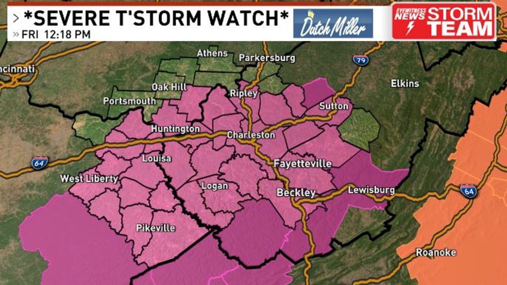
Severe thunderstorm watch issued for Friday


TOPICS:
Severe Thunderstorm WatchCHARLESTON, W.Va. (WCHS) — After a quiet start to our morning, the atmosphere is changing quickly on this Friday Afternoon.
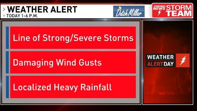
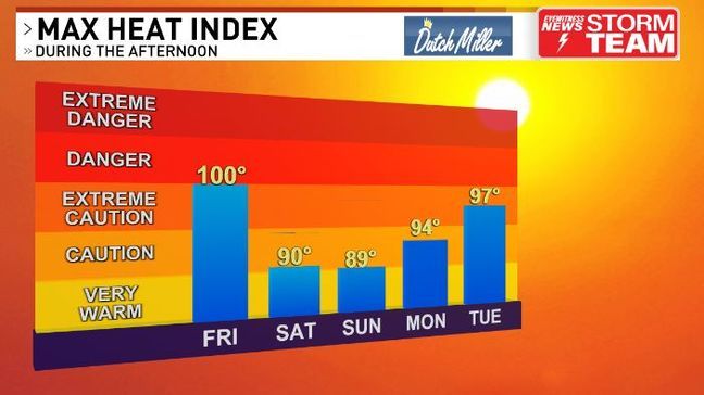
While temperatures are in the upper 80s to around 90, it feels much hotter than that due to high humidity. Our heat index should peak out around 100 degrees before a line of storms moves in later this afternoon.
Given this very unstable atmosphere, along with a belt of faster winds aloft, severe thunderstorms are a good bet for many. The main risk would be strong straight-line winds that may exceed 60 mph in some spots. Localized heavy rainfall could also lead to isolated and brief high water.
Could there be small hail and some rotation in a cell or two? Possibly, but those are lesser risks overall.
As a result, the Storm Prediction Center has issued a severe thunderstorm watch for most of our region until 7 p.m. This means conditions are favorable for severe thunderstorms.
While the heat index is high this early-afternoon, it won't be as muggy as we head into the weekend. Therefore, the heat index won't be as high - still rather toasty, though.
Muggy air looks to return next Tuesday, our next best chance for showers and storms after today.
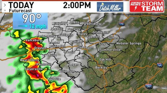
It looks like the strongest storms will move towards the Tri-State around 2 p.m.
At this point, Charleston will be hot and muggy around 90 degrees under filtered sun. A spotty shower could form out ahead of this line, but many will stay dry until mid to late-afternoon.
By 4 p.m. our futurecast shows a nasty line of storms near Ripley down to Charleston and also down along the West Virginia Turnpike.
Winds can exceed 60 MPH in spots here, which can topple trees and lead to power hits for some of us.
Make sure you have a sturdy structure close by and get away from windows if a warning is issued for your area. Also, if you have family or friends out camping - make sure to give them a heads up.
There is a silver lining with these stronger storms this late-afternoon - as our atmosphere could very well be 'gassed' this evening.
This suggests a drier evening with cooler temps down into the 70s - though it will still be muggy.
If you're heading down to the Charleston Sternwheel Regatta to watch Montgomery Gentry or to visit us for WCHS-TV night, the forecast looks better by then.
After storms blow through this late-afternoon, the evening and the weekend looks much better for the Regatta. The weekend will be toasty, but it won't be as muggy under some sunshine.
If you're thinking about firing up the grill, you are in luck. This weekend will be a warm one, but not as muggy under plenty of sunshine.
We'll be watching Hurricane Beryl into next week. It looks to make landfall in South Texas on Monday and the remnants could spread tropical moisture our way late next week.
Storm-Team Weather